An ice storm warning issued earlier Friday has now been extended to more metro Atlanta counties.
Up to an inch of ice is possible for areas under this warning, and widespread power outages are likely. Significant amounts of ice accumulations will make travel dangerous or impossible Saturday night through at least Monday.
Gov. Brian Kemp issued a State of Emergency for the whole state.
This is an evolving weather situation. Severe Weather Team 2 is going over the updating timing and impacts for your area, LIVE on Channel 2 Action News starting at 4:00 p.m.
[DOWNLOAD: Free WSB-TV Weather App for alerts wherever you go]
WARNINGS AND WATCHES
An ice storm warning is in effect for the following counties:
- Banks, Barrow, Bartow, Catoosa, Chattooga, Cherokee, Clarke, Clayton, Cobb, Dade, Dawson, DeKalb, Douglas, Elbert, Fannin, Floyd, Forsyth, Franklin, Fulton
- Gilmer, Gordon, Greene, Gwinnett, Habersham, Hall, Hart, Henry, Jackson, Lumpkin, Madison, Morgan, Murray, Newton, Oconee, Oglethorpe, Paulding, Pickens, Polk
- Rabun, Rockdale, Stephens, Taliaferro, Towns, Union, Walker, Walton, Warren, White, Whitfield, Wilkes
- Clay County, North Carolina
Areas north and east of Atlanta will have the most significant impacts from 1/2” to 1” ice accumulation and gusty wind. This will lead to widespread, long-duration power outages and impossible travel in many areas.
In Atlanta, 0.25 to 0.50 inch ice will also lead to power outages and dangerous travel, but impacts are likely to be a little less severe and widespread.
A winter storm watch will be in effect for the following counties starting Saturday through Monday morning
- Baldwin, Butts, Carroll, Coweta, Fayette, Glascock, Hancock, Haralson, Jasper, Jefferson, Jones, Putnam, Spalding, Washington
- Cleburne County, Alabama
TIMING
We will start off dry Saturday morning and moisture will begin to move in mid-morning in far north Georgia.
By afternoon and evening, increasing moisture will allow precipitation to fall as a freezing rain–cold rain mix. This will continue overnight into the day on Sunday before changing over to rain Sunday night.
Widespread melting is not expected to occur until Tuesday.
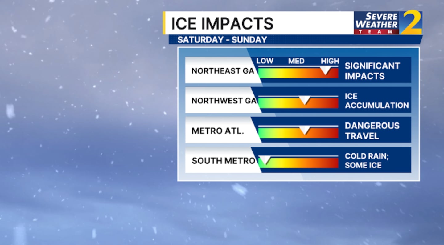
ICE IMPACTS
Severe Weather Team 2 Chief Meteorologist Brad Nitz says most of our area, including metro Atlanta, is looking at a quarter inch to a half inch of ice accumulation Saturday and Sunday.
Up to an inch of ice is possible for the areas under the ice storm warning.
A quarter-inch of ice can add up to 400-500 pounds of weight on powerlines. On top of the ice, winds will also be gusty. This will lead to a higher probability of downed trees and powerlines.
STORM PREPARATIONS
Complete your storm preparations today or the latest by the early hours of Saturday morning.
Severe Weather Team 2 Chief Meteorologist Brad Nitz shared this winter preparedness checklist for your home and car. Make sure you have the essentials, charge your devices, and check in with your loved ones who may need help with their preparations. Don’t forget to bring your pets in.
ROAD IMPACTS
State officials are urging everyone to stay off the roads, especially Saturday afternoon through Monday afternoon.
“If there is any time that you are going to heed a warning, it is during an ice storm situation. Ice travel is no travel,” GDOT spokeswoman Natalie Dale told Channel 2 Action News This Morning. “It is not limited travel. It is if you need to be somewhere, you need to cancel your plans.”
[UPLOAD PHOTOS: Share your weather photos with us here]
©2026 Cox Media Group


