
ATLANTA — North Georgia and parts of metro Atlanta are getting much-needed rain, and it could continue through most of the day.
Hurricane Nate weakened to a tropical storm overnight, and then to a tropical depression just before 11 a.m. Sunday.
Severe Weather Team 2 is tracking the timing of impacts in your area on Channel 2 Action News.
"Nate will continue to weaken as it moves toward northeast Alabama later today, before quickly pushing off to the northeast," Meteorologist Brian Monahan said.
Nate made its second landfall as a Category 1 storm around 1:30 a.m. ET Sunday along the Gulf Coast near Biloxi, Mississippi, with maximum winds of 85 mph. It slammed some Mississippi and Alabama communities with a storm surge of between 4-5 feet, according to ABC News.
Nate made its first landfall Saturday night as a Category 1 storm near the mouth of the Mississippi River on the southeastern Louisiana coast.
[Download the free Severe Weather Team 2 app for alerts in your area]
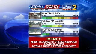
LOCAL IMPACTS
A flash flood watch is in effect for the northern half of the area through Monday morning for the potential of 2-4 inches of rain. Rainfall amounts farther south and east will be significantly less than that, Monahan said.
“For a lot of us, this is much-needed rain, as it hasn’t rained since Irma almost a month ago,” Monahan said.
Flash flood watch over the N GA mountains and NW GA tomorrow afternoon through Monday morning @wsbtv pic.twitter.com/3Glv5ATeyt
— Brian Monahan, WSB (@BMonahanWSB) October 8, 2017
Strongest wind moves through N GA tomorrow afternoon and early evening -- gusts 40+ possible. pic.twitter.com/FuFQOSd498
— Brian Monahan, WSB (@BMonahanWSB) October 8, 2017
There is no tornado threat as of Sunday afternoon.
[READ: Power crews prepare for impact of Nate in Georgia]
OTHER IMPACTS
More than 100,000 were without power in Alabama and Mississippi as of Sunday morning. The majority of those without power were in Mobile. There are also reports of stranded drivers, so police advised people to stay off the roads Sunday.
A tornado watch covering most of southern Alabama and part of the Florida Panhandle was issued around 2:30 a.m. ET. It is in effect until 11 a.m. People were advised to shelter in place.
[PHOTOS: Hurricane Nate lashes Gulf Coast before weakening to tropical storm]
Parts of Mississippi saw significant flooding on roads early Sunday.
TRENDING STORIES:
- Tropical Storm Nate's forecast path shifts east into Georgia
- Investigators warn of fentanyl-laced cocaine after death of doctor and friend
- Car dealership worker robbed, 3 Jeeps stolen
PLANNING AHEAD
Ahead of Nate's landfall, the governors of Louisiana, Mississippi and Alabama all issued stern warnings to residents.
Louisiana Gov. John Bel Edwards declared a state of emergency on Thursday and warned residents to prepare for heavy rain, storm surge and high winds.
"No one should take this storm lightly," Edwards said at a news conference Friday. "We do want people to be very, very cautious and to not take this storm for granted."
In Mississippi, Gov. Phil Bryant on Friday declared a state of emergency in several southern counties in preparation for the storm.
"If you are in an area that has flooded, I would recommend you evacuate that area until the storm has ended and the water has receded for your own personal safety and for the safety of the first responders that will be responding in the event you are trapped," Bryant said at a press conference Friday.
Alabama Gov. Kay Ivey issued a statewide state of emergency that went into effect Friday morning. "It has become clear that Alabama, especially on our coast, will experience some of the worst conditions from this storm," Ivey said at a press conference Friday. "Alabamans, you must prepare and be vigilant. This is serious business."
Florida Gov. Rick Scott also declared a state of emergency in some counties.
Stay with WSBTV.com and watch Channel 2 Action News throughout the day for the latest forecast updates.
ABC News contributed to this report.
Cox Media Group


