ATLANTA — A winter storm moving into north and central Georgia is prompting new warnings from the National Weather Service. An Ice Storm Warning has been issued for much of the area, including metro Atlanta.
SCHOOL CLOSINGS: These districts are closed or going virtual Monday
Tracking the latest forecast LIVE on Channel 2 Action News.
10:22 p.m.: Sleet has been reported at Hartsfield-Jackson Atlanta International Airport.
10:17 p.m.: Power outages are beginning to be reported in north Georgia and metro Atlanta. As of 10 p.m., around 4,000 Georgia Power customers and over 1,000 Georgia EMC customers are without power.
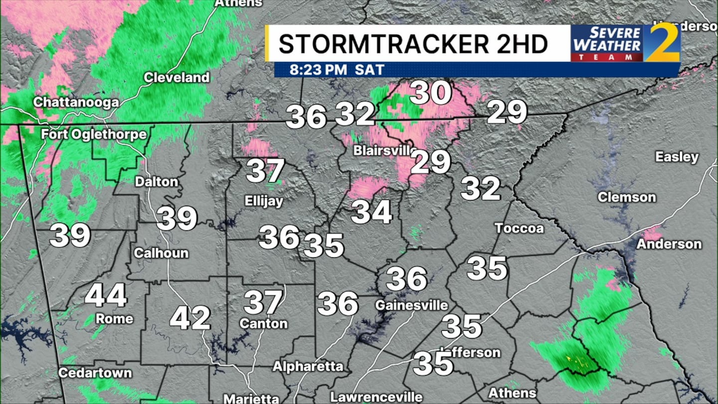
8:25 p.m.: The cold air is moving in quickly from the northeast. Icing conditions will spread across north Georgia and into the metro area over the next few hours.
6:50 p.m.: Severe Weather Team 2 Chief Meteorologist Brad Nitz said temperatures drop to freezing or just below around midnight, and we will see hours of ice accumulation.
Ice storm warnings remain in effect Saturday for much of metro Atlanta and north Georgia.
Wintry mix is starting in Smyrna now. pic.twitter.com/WDQ3ZsqOAL
— Brad Nitz (@BradNitzWSB) January 24, 2026
4:50 p.m.: Georgia National Guard has been activated for the ice storm. They are staging and will be deployed to areas in Northeast Georgia as needed.
“After consulting with Major General Wilson and our readiness team, I’m activating 120 Georgia Guard members for deployment to Northeast Georgia today. These Guardsmen will be organized into strike teams and further strengthen our response in the hardest hit areas as we do everything possible to keep Georgians safe. Please join Marty, the girls, and me in keeping them in our prayers,” Kemp said.
3:21 p.m.: The City of Atlanta has begun treating city roadways in preparation for winter weather, with 23,000 tons of salt and 3,300 gallons of brine available, an ATLDOT spokesperson said.
The city is actively pretreating Priority 1 and 2 roadways and bridges. Crews are monitoring conditions and forecasts and plan to adjust operations as needed, the spokesperson said.
2:50 p.m.: State offices will be closed Monday, Gov. Brian Kemp announced Saturday. “I have instructed state employees not involved in weather response activities to work from home if their office or residence is in the blue shaded counties,” he said.
With conditions in North Georgia expected to remain potentially hazardous through Monday, I have instructed state employees not involved in weather response activities to work from home if their office or residence is in the blue shaded counties.
— Governor Brian P. Kemp (@GovKemp) January 24, 2026
State offices in these… pic.twitter.com/duGVjmARNS
1:41 p.m.: Severe Weather Team 2 Meteorologist Brad Nitz reports icing began in far north Georgia early Saturday. Freezing rain will spread into the metro area Saturday evening and continue overnight through Sunday morning.
er App for alerts wherever you go]
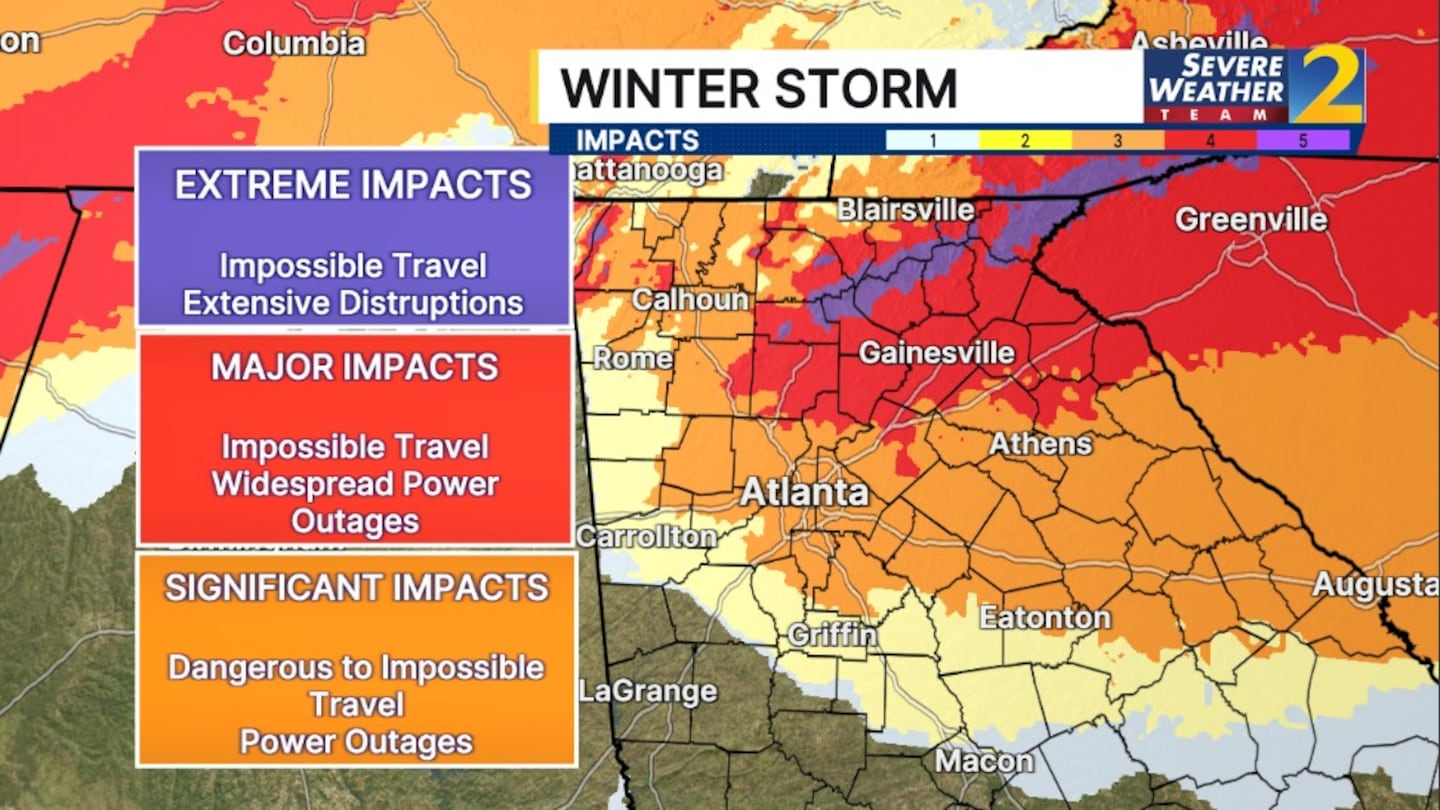
This is the first Ice Storm Warning issued for the region since February 2014.
A Winter Storm Watch has been upgraded to a Winter Weather Advisory for far southern counties, while the rest of north and central Georgia remains under an Ice Storm Warning. The most widespread and potentially destructive ice impacts are expected on the northeast side of the metro area, where conditions will be most favorable for prolonged icing.
[INTERACTIVE: StormTracker 2HD Radar]
Through the evening hours as cold arctic air settles in underneath the rain, we will see the transition to freezing rain.
The greatest icing will happen overnight Saturday into Sunday. Areas will see from a quarter inch to as much as an inch in areas in the northeast part of the state.
Gusty winds and ice will likely lead to power outages.
Temperatures drop to freezing or just below around midnight, and we will see hours of ice accumulation, said Severe Weather Team 2 Chief Meteorologist Brad Nitz.
That will lead to significant impacts.
The ice continues through daybreak Sunday then a brief warmup. That will allow for some melting but don’t expect it all to melt before we get the coldest air of the season so far.
There also will be a few thunderstorms on Sunday afternoon, primarily south of I-20.
[UPLOAD PHOTOS: Share your weather photos with us here]
HOME WINTER CHECKLIST
- Select foods
- Disposable dishware (plates, bowls, utensils)
- Specialty items (medications, infant formula, etc.)
- Portable radio (AM/FM WX radio and batteries)
- Warm clothing (hats, mittens/gloves, warm coats, boots)
- Flashlights and extra batteries
- First aid kit
- Extra blankets
- Cellphone (fully charged)
- Firewood (for wood fireplaces)
- Matches (for candles and gas fireplaces)
CAR WINTERIZATION CHECKLIST
- Check engine fluid levels (oil, coolant, washer fluid, etc.)
- Test battery and replace if necessary
- Use deicing washer fluid
- Switch to synthetic oil (handles the cold better)
- Inspect tire tread (replace at near wear limit)
- Test headlights and tail lights
- Add and inspect winter survival kit
HOME WINTER SURVIVAL FOOD CHECKLIST
- Canned fruits and vegetables
- Bread and condiments (keep bread frozen to last longer)
- Cereal and toaster pastries
- Crackers, nuts, fruit bars and chips
- Soups (some soups require water or heating)
- Meals ready to eat
- Bottle water
- Cookies and hard candy
CAR WINTER SURVIVAL KIT CHECKLIST
- Flashlights and extra batteries
- First aid kit
- Ice scraper
- Snow shovel
- Blankets/sleeping bag
- Non-perishable food
- Bottled water
- Booster cables
- Extra clothing (hats, mittens/gloves, warm coats, boots)
- Sand/kitty litter (used for traction)
- Cellphone and charger
- Flares/triangles and other bright objects.
©2026 Cox Media Group


