ATLANTA — Strong to severe storms moved through parts of North Georgia again Wednesday night, but this time around they didn’t pack as much of a punch as Tuesday’s storms did.
Earlier in the day, all of North Georgia was under a Level 3 threat for a severe storm and much of the southern metro was under a Tornado Watch.
That watch was able to expire around 8 p.m. with a few counties in extreme North Georgia still under the tornado watch, which was set to expire at 10 p.m.
Another line of storms began moving into Georgia in the Northwest corner of the state around 7 p.m., sparking some severe thunderstorms throughout the evening.
HERE IS A LOOK AT HOW THE DAY UNFOLDED:
11 p.m.
A Severe Thunderstorm Warning has been issued for Fulton, Cobb and Douglas counties until 11:15 p.m.
8:51 p.m.
A Severe Thunderstorm Warning has been issued Pickens and Dawson counties until 9:15 p.m.
8:23 p.m.
A Severe Thunderstorm Warning has been issued for Gilmer and Gordon counties until 8:45 p.m.
8 p.m.
Most to the Tornado Watch for the southern part of the Atlanta metro has been allowed to expire. Currently, there is only a Tornado Watch in place for Fannin, Gilmer, Gordon, Murray, Walker and Whitfield counties until 10 p.m.
TORNADO WATCH CANCELED FOR DADE, WALKER, CHATOOGA, AND CATOOSA COUNTIES.
Posted by Glenn Burns on Wednesday, April 6, 2022
6:26 p.m.
A flash flood warning has been issued for Butts, Lamar and Upson counties until 11:15 p.m.
5 p.m.
The watch has been extended to Catoosa, Chattooga, Dade, Fannin, Gilmer, Gordon, Murray, Walker and Whitfield counties until 10 p.m..
4:53 p.m.
A severe thunderstorm warning has been issued for Jasper and Putnam counties until 5:30 p.m. The National Weather Service said this storm could contain golf-ball-sized hail.
Severe Thunderstorm Warning for Jasper and Putnam County until 5:30pm.
— Brad Nitz (@BradNitzWSB) April 6, 2022
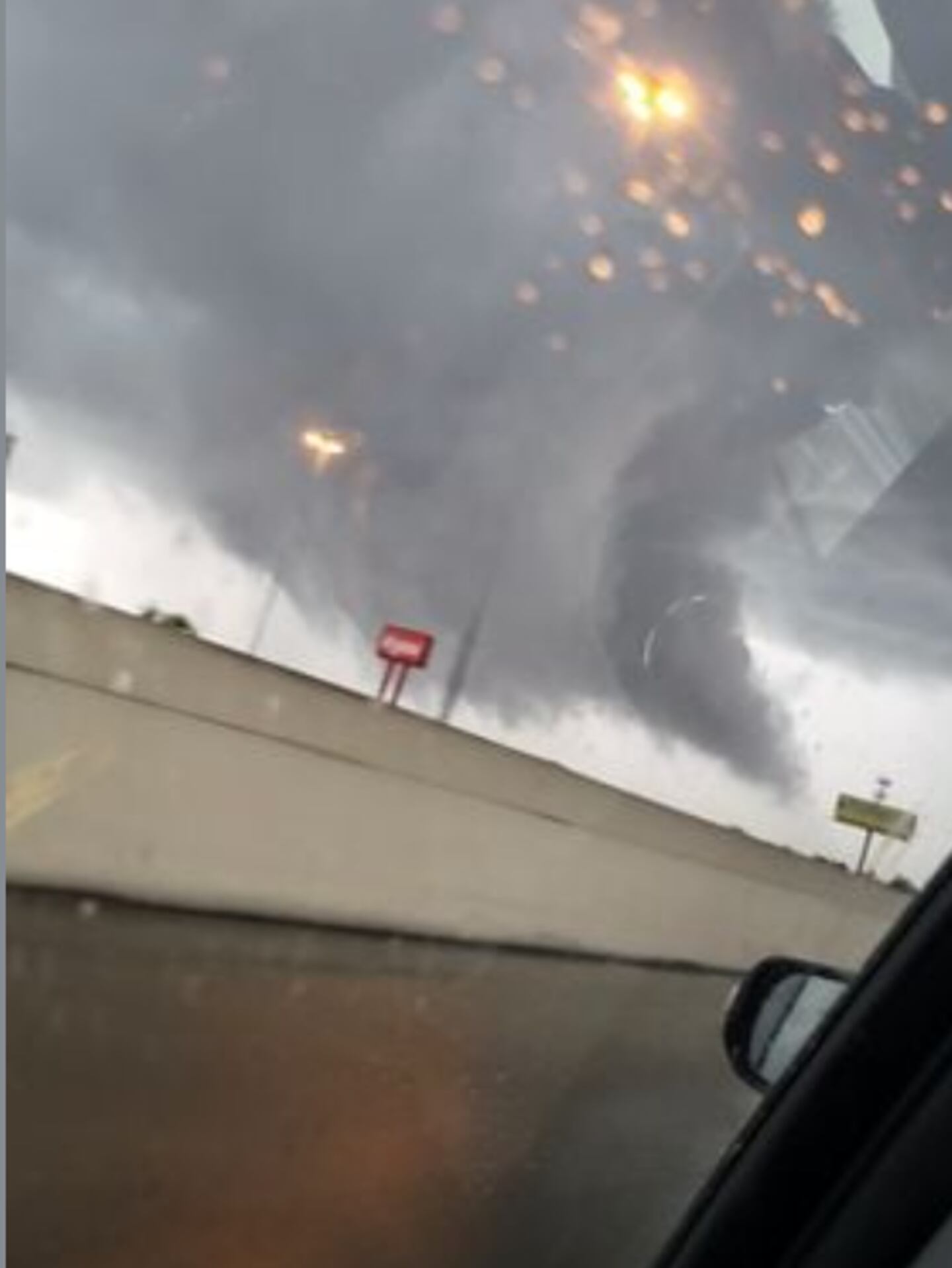
4:28 p.m.
A Channel 2 Action News viewer sent this image to Severe Weather Team 2 Chief Meteorologist Glenn Burns of a funnel cloud in Cordele, in south Georgia.
3:43 p.m.
Strong storms are moving into metro Atlanta now.
Here we go — storms with heavy rain, lightning… wind gust/hail threat rolling across I-20 now.
— Brian Monahan, WSB (@BMonahanWSB) April 6, 2022
They’re training west to east potentially… could enhance flash flooding risk. pic.twitter.com/TvhWYV8ziz
2:07 p.m.
Gov. Brian Kemp has declared a State of Emergency after Tuesday’s storms devastated parts of southeast Georgia near Savannah, killing one person.
1:40 p.m.
A tornado watch has been issued for Coweta, Heard, Irwin, Fayette, Henry, Jasper, Morgan, Meriwether, Putnam, Pike, Troup, Upson, Clayton and Spalding counties until 10 p.m.
JUST IN: Tornado watch for most of our area south of I-20 (for now) until 10pm @wsbtv pic.twitter.com/ZGETyx6EUw
— Brian Monahan, WSB (@BMonahanWSB) April 6, 2022
[DOWNLOAD: Free Severe Weather Team 2 App for alerts wherever you go]
Here’s the latest on what you need to know:
- Today starts off muggy but drier conditions start around lunchtime.
- By about 2 p.m. storms will begin to form south of I-20 with the daytime heating.
- Afternoon storm impacts are damaging 60+ mph wind gusts, hail; tornado or two is possible
- A cold front will begin to move into the state around 8 p.m. and a line of storms will form ahead of it, impacting the metro around 11 p.m.
- Evening storm impacts are also damaging 60+ mph wind gusts, hail; tornado or two is possible
HAIL RISK TODAY: As storms develop later this afternoon, one of the risks will see today is large hail -- especially on...
Posted by Brian Monahan, WSB on Wednesday, April 6, 2022
RELATED NEWS:

©2022 Cox Media Group