ATLANTA — Get ready for all kinds of weather on Saturday. Severe Weather Team 2 is tracking a chance of severe storms early Saturday morning and the return of winter weather right behind it.
Once the severe threat ends, cold air moves in and there is a chance for a wintry mix and snow showers.
Watch Channel 2 Action News Saturday A.M. for the latest LIVE updates on weather conditions. Severe Weather Team 2 Meteorologist Jennifer Lopez will have an updated weather forecast and the latest weather conditions beginning at 5 a.m.
[DOWNLOAD: Free Severe Weather Team 2 App for alerts wherever you go]
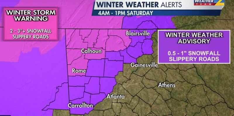
A winter storm warning has been issued for Dade, Walker, Catoosa, Whitfield, Murray, Fannin, Gilmer, Chattooga, Gordon and Floyd. The warning started at 4 a.m. Saturday.
A winter weather advisory has been issued for Union, Towns, Pickens, Dawson, Lumpkin, White, Bartow, Cherokee, Polk, Paulding, Cobb, Haralson, Carroll and Douglas counties, the advisory also started at 4 a.m. Saturday.
Winter Storm Warning for NW Georgia now in pink. pic.twitter.com/vGcsTgMt6h
— Brad Nitz (@BradNitzWSB) March 11, 2022
Dalton Public School said the SAT scheduled for Saturday, March 12 at Dalton High School Catamounts has been postponed because of the weather. The SAT scheduled at Rome High School has been rescheduled for March 26.
The City of Atlanta is also opening two warming centers starting at 7 a.m. Saturday at the Old Adamsville Recreation Center at 3404 Delmar Ln NW, and the Central Park Recreation Center at 400 Merritts Ave. NE. They will remain open until 10 a.m. Sunday.
Here is what else to know as we head into Saturday morning:
- Level 2 out of 5 threat for severe storms mainly south of I-20.
- Behind the cold front, rain will likely change over to snow in northwest Georgia.
- Accumulation in the mountains generally ½-1 inch, with isolated 2 inch totals possible in higher peaks
- Temperatures will be down into the 20s by Sunday morning.
[INTERACTIVE: StormTracker 2HD Radar]
©2022 Cox Media Group


